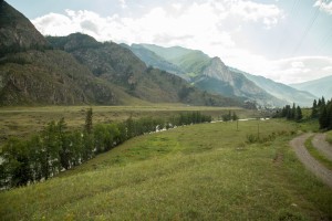
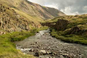
I woke up in the morning with a slight headache. Looks like on yesterday I drank too much sparkling wine. Or I just got a road sick. Or may be it was mountain sickness? Anyway, by 10AM I drank a cup of tea, finished my breakfast and was ready for a new adventures prepared for us by my friend, a professional off-road driver, hunter and fisherman. Nothing to say we were so lucky with our guide and trip programme for the whole week! On the picture below you can see Chuya river nearby Belyy Boom. It is cold and very fast river with a bit muddy water.

Part one. “Undisclosed location”
We decided to start our day with driving up to the mountain with radar station on top. I was told we were going to unknown, hard-to-get and even a secret place. No wonder I was asked to not make any pictures of neither a station or its equipment. I hope, no need to explain why. So, we packed our staff back to the car, checked out of the place we stayed overnight, crossed Chuya river over the old wooden bridge and drove upon a hill towards mountain pass.
What I really enjoy in Mountain Altay is there are no moskitos, black flies, horse-flies at most of its part. You can walk, hike and do lots of activities without applying repellents on your skin and clothes. Does anyone have a logical explanation to this?

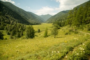
Typical taiga forest. Siberian fir, cedar, black currant, raspberry and honeysuckle bushes. We drove through the valley and then moved up to the top.
After 25 minutes driving on very steep gravel road we finally reached the summit. Here is our car. Turbo diesel, 4.2 Littres engine, 38 inches wheels. If you really interested in visiting mountain Altay, I will post my friend’s contact details here in this blog at the end of our trip.

If you drive down to the valley below, then, after having a two days journey, you will get to Kuray steppe. They say, you can get unforgettable experience by doing that. Well, hopefully one day we will do it.

Subalpine flora… Afar from here, there were grazing horses. We decided to drive a bit further to overlook valley and mountains from another side.

The summit was covered by bushy carpet of grass and lichen, very common for tundra and forest-tundra. Sharp stones stick out almost everywhere.

At some places there were stone debris. We are still thinking whether they were put there by humans or not.
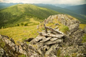
Just a heap of rocks, covered with red lichen.

Dwarf shrubs were everywhere, so my feet were literally sinking in their soft branches.

Also, it was very cold at the summit, that is why we were wearing beanies and hoodies.

After a short walk we drove back the same road down to the Chuysky tract.

Part two. “The Chuysky Tract”
We have made a few stops on our way to Kuray steppe. One of them was a rafting spot called “Hippo”.

Then we had a lunch at a cafe nearby the road. I would say that average lunch cost for two people would be approximately 300 rubles. We ordered lamian, borsch, two course of manti and black tea with lemon. What I have noticed about locals is they never rush. Unlike them, Russians are always stressed and in a hurry. Just in case, just because we can. Even when we are having vacations. These two locals were very calm when they were replacing one of the truck’s tire. Before that, they had a lunch in the cafe and they did express no dissappointment about the problem.

The Northern Chuya Ridge is incredibly beautiful place. I was told by a motorcycle travelers that was the best part of their round the world trip. Unbelievable beautiful.

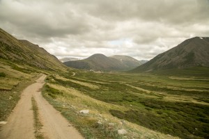
The main feature of the Chuysky tract is you never see same landscapes. Behind every road turn there is totally different view of another mountain, another steppe, another river bank or standalone pine tree growing on top of the single rock. Seven years ago, when I was riding a motorcycle here for a first time down to Mongolia, I was making stops every 500 meters. Because I was simply overwhelmed by the scale and the beauty of Mountain Altay landscapes.

Very famous Kuray steppe, the Northern Chuya ridge and Maashey glacier. They say, during winter times, temperature in Kuray steppe can plummet down to -60C and even lower! Climate of Kuray steppe is very close to the areas near Arctic pole. And because of that locals receive benefits from the government.

We made a stop in Kosh-Agach to buy a pot, frying pan and steel cups. Kosh-Agach is an administrative center of Kosh-Agach region and it has a population of 9200 with majority of Kazakh people. It seems to me this town has almost no trees, bushes or grass. And as we also noticed, it has absolutely no smell. Surprise.

Part three. “Border zone permit Soloneshnoe”
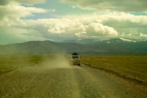
After visiting Kosh-Agach we drove towards border checkpoint, over passing UAS four-wheel drive cars and other slow vehicles on the way. We had to drive 30 kilometers from Kosh-Agach to border check point. I have to say our car was good both on a highway and off-road. I have never been driving 100 kph on a gravel road before.
What a wonder, there is almost no grass in the steppe. The only plants can survive here are very short and small. Anyway, you can still observe some sheeps and even cows here. No idea what they eat.

During the passport control at the border point we realised how close we were to a failure. It turned out that we had a high chance of being unable to continue our trip. Just keep this in mind – if you left Russia and live overseas, you can face some issues while trying to cross Russia’s border zones without being registered in Russia on a permanent base. I have no idea how, but my friend got everything sorted. Let’s say he is a very charismatic person.

We have seen heaps of unelievably beautiful landscapes on the way to Dhumalinskie springs. Needless to say, road surface was in a relatively good condition for most of the way, but at the end there were bumbs and pot holes.

You can met some local fishermans near small and pure mountain streams. Unfortunately, we didn’t go fishing because of lack of time.
We have seen dozens of gophers, however, I didn’t manage to make any descent pictures of them due to the distance. Always take zoom lens with you. Sincerely yours, Captain Obviousness.


Part four. “Dzhumalinskiy Teplyi Kljuch”

-Warm springs? Are you kidding? I didn’t know there are geothermal springs in Altay! Are they really hot? о_О

Indeed, there are warm but not hot! radon springs with a temperature of 18C throughout the year. They say bathing in these pools has a therapeutic effect for a number of diseases. However, I was quite skeptical. Personally, I truly believe you have to be very desperate in traditional medicine in order to make such a long and exhausting trip to the middle of nowhere for… swimming in radon springs.

Unfortunately, it was a very cold day so, we decided to skip bathing. In addition to that, there was no sauna nearby the springs to warm after bathing.

And as we found out later, when we came back to the civilization with the internet (and hot water!), we shouldn’t have regret the fact we skipped bathing in radon pools. The thing is, health effect of radon is based on alpha radiation which is not really good for your health. And actually, it is considered to be a health hazard due to its radioactivity. In a nutshell, bathing in radon springs, should be assigned only and only if healing effect you get will be a way bigger than the damage you get after being exposed to the radiation, which occurs during the half-life of radon. If you don’t have any health issues, you should think twice before bathing in radon pools. Well, good to know.

Part five. “Teplyi Kljuch Pass”
We spent half an hour driving to the top of this very hard and dangerous pass. At some places there was no road but just heaps of big stones and rocks. For example: UAZ-452 Bukhanka or pan loaf spends 2 hours to get to the top of the pass and drive down.

All the time while we were driving through the pass I had a feeling we were at Putorana plateau. Landscapes we saw remind us those landscapes we have seen in the “Territory” (2014) movie.

Altitude of Teplyi Kljuch Pass highest point is 2920 meters above sea level.

From the other side of the pass you can see Ukok plateau – southern most part of Altay near to the border of Mongolia, China and Kazakhstan.

There was stock of camels, left down in the valley by it’s shepherds for the summer time.

Part six, the final. “Kalgutinsky tungsten-molybdenum mine”
The final destination for today was tungsten-molybdenum mine, based in 1930 and completely abandoned and devastated in 2008.

Guys, you can’t even imagine the size of this place. Your mind is simply crushed by gigantism of the mountains around the mining camp.

After driving through the whole valley, we drove up to the one of the mine entrance.


Near the entrance, there were broken trolley, remains of construction materials, electric wires and steel cables.

Unfortunately, entrance to the mine was completely blocked by ice, so we didn’t manage to move any distance.

After walking some time nearby the debrees, we decided to leave.

It was getting dark, so we had to drive back over the pass back to the border post and further. We arrived in Kosh-Agach late in the night, around 1AM.


To be continued…

Ivan Grigoryev's Blog
Living in New Zealand. Blogging about the country, beautiful places, everyday life.
Do a skydive - halfway completed; get 1400 - still working on; reach 300kph - completed by 96.6%