I wouldn’t say it is a walk because in despite of overal length of almost 7 kilometers, track is quite tough and I would say even equals to famous Tongariro Crossing, and sometimes at some places it is even harder! Unfortunately none of top results generated by search engines hasn’t mentioned about track difficulties and hasn’t shown incredible amount of steps this track has. There is nothing like this on official Department of Conservation website – just a tiny description and couple of images from the top.

We decided go there before winter come to New Zealand, at one of long weekend at the end of April. Saturday, we are packing our backpacks: water, tissues, fruits, chocolate bars; couple of my colleagues are joining us and we leaving Auckland! It is approximately two hours driving before carpark in subtropical forest. I highly recomment do not be in rush because, during weekend and especially public holidays motorways are full of speed cameras. For example, I’ve noticed undercover police van parked at roadside near descent after motorway ramp where you have to drive 90kph but your car is going to drive 100 and higher. I haven’t mentioned cars which were stopped by police on the motorway itself. All right, we are driving on State Highway 25, then entering Thames from south and making right turn to Banks Street near BP fuel station and than turning right to Parawai Road and then following Kauaeraranga Valley road. After 10 kilometers you will drive on dirt road, cross one way bridges, cross of ther rivers and say hello 4WD!! Relax, road quality is quite affordable for a usual car 😀

💡 After 13км you will reach Kauaeranga Visitor Centre, where you can buy a guide for $2, or learn with information decks on the walls, listen audio and as an option visit a toilet. There are at least 25 another tracks in Coromandel forest. From both side of the road there are campsites; some of them work every year, some of them during summer time only. Staying for night will cost $10 for adult, , $5 for a 5-17 years old, preschool kids (0-5 лет) allowed for free. You can pay via self registration on web sites or using honesty boxes, or eftpos and VISA card in Kauaeranga Visitor Centre.
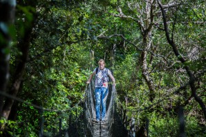
Driving last 9 kilometers, parking car, and wearing hiking shoes. There are cleaning brushes at the entrance which you must use to clean your shoes before and after visiting forest. Else, you might bring fangus spores very dangeros for kauri trees, overal population of them is just 1% from original population before Europeans came. After 5 minutes of walk we are crossing suspension bridge. If you can’t read: maximum load one person! 🙂

I’m sure, during the summer you can cross river without using a bridge:

Next 20 minutes we walked on a quite wide and flat trail:

Some times you see borders and wooden bridges via small creeks:

Watch you steps before descent to small waterfall:

One of numerous creeks with cold and fresh water. I washed my face. It was very wet after rains in the forest:

And then steps begun. Made in stones, built using some blocks or cobbles of different colur and shape, covered with moss and grass… Paved by leafy serpentine among the thickets of grass, shrubs and trees, thousands of them! 🙂


All this is historical route for transporting goods and food into logger camps using mules:

Almost everyone creek here has alternative way via suspension bridge, just in case of floods after rains. Anyway it is pretty easy to walk across:

Very beautiful! I wish, there could be tiny fishes:

My colleague from Poland asking me whether it is safe to drink this water. Of course! You are in New Zealand! 😀

If I am not mistaken, this is somekind of marble (looks very unusual with green background):

Very high ascend and wet air make us suffer from lack of oxigen, I tried to breath deeper but it didn’t helped:

A few “windows” in trees and bushes give you relief and breath of fresh air and also give you a chance to look through them:
Wooden steps, armed with armature:

Sometimes we met yellow bricks road:

Another small waterfall. I wish I could put my backpack on ground and swim there for a while:

Another suspension bridge. We didn’t realize but we would cross that creek under if you could see trail. Signs do not recommend to use bridges without real need:
After rains, everything in forest was wet, water was dripping everywhere. Amazing, but some of this steps are made using natural materials, like for example, that roots from a living tree:

In the days of kauri felling thousands of trees in the valley was cutted: logs were cut down, cleaned of twigs and branches, aligned along the length and fused along the rivers through special trays as well as roads, built of other smaller logs or rails, and then stocked up for transportation to sawmill in Auckland:

Small stream near Hydro Camp

Somewhere in the middle of track I started feeling leg bones and especially where are they located and how do they work 🙂 I can’t imagine, but someday ago people transported huge kauri logs here using bulls and small steam trains:

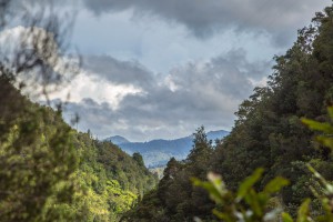
As soon as we approched to opened space we could see ranges, rocks, gorges, beautiful landscapes and other witnesses of an active nature of Coromandel region, like for example, extinct Tauranikau volcano:

Nearby we found kauri log lying on ground and counting down his days. Most of the cutted trees were exported, some of them was used for making furniture, sleepers, or building houses and boats:

Platou which we just passsed:

Around 18 million years ago, volcanic activity created Coromandel ranges and underwater ridge Colville. Active geotermal systems, similar to existing one near Rotorua were here around 6 million years and then (5-2 million years), moved down south to create Kaimai ranges, leaving deposits of gold and silver, digged out later during Coromandel gold rush:

If I am not wrong, we have to climb on the top of this rock 🙂 Should take another 1.5 hours of hiking:

And this is a hut. Not the classic one

It is a small houses with bunks, mattresses, toilets, cold shower, gas stove (bring your plates) and barbecue. You have to book in advance. Staying for night will cost $15 for adult, $7.5 for a 5-17 year old kid, and free for preschoolers:

If you walk down 5 minutes from hut, you will see reminds of Dancing Camp Dam, second big dam built in 1921. During year 1920 there were build over 40 dams using kauri trees cutted nearby, which allowed to transport wood from another unreachable regions of valley:

Gloomily.. There were many kauri trees sometime ago:

We are ahead of the final and most difficult part of the route. We have to ascend next 40 miuntes through very well maintained step track for 1kilometer, on top to Pinnacles summit (~760m):

You cannot find more extreme cardio training! Meanwhile, ascend become harder and harder and views become coolder and cooler:

How to ban people do not go at dangerous places? Of cours do not place a sign “access forbidden” 🙂

-“Cossack attack!” we heared suddenly through bushes. -“Cossack attack!” repeated again and we saw old asian guy. -“Wow! Where did you come from?”, I asked him. -“Mongolia!” -“Which town?” -“The capital!” and opened his tablet to send a message to his friends about cossacks or may be just to make a picture of forest, ranges and small town at Pacific Ocean coast:

So, actually you have two options: calm down and stop climbing right here (dried brooms below – are died kauri trees):

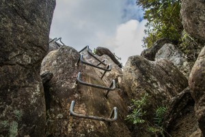
or continue and search for extreme and thrill – there is a ladder for you:

Almost vertical, it remind me sheep ladder or ladder in fire department:

We haven’t finished yet! 🙂 There is another steps in stones:

It remains a little thing: to show the wonders of skill and ingenuity:

I’ll show you how steep is there and:

also variety of steps in stone (some kind of ladder):
Walkers on the LEFT! 🙂

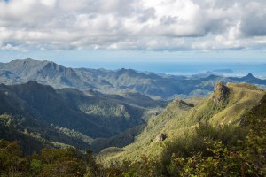
There is wide platform on top of Pinnacles, chilly wind and amazing panoramio view: open your backpack, wear warm clothing, eat some snack, drink a hot tea your level of brutality will just increase 🙂

We realised it is make sense to stay overnight in hut only when we had reached summit on Pinnacles – it is affordable to walk track during the day (as we did), but I think it is better have a rest and do another day of hiking. As they say, you can watch really cool sunset from the summit and also, you can try another tracks and trails with waterfalls, dams and other interesting places ❗ Please take care at the summit!


Ivan Grigoryev's Blog
Living in New Zealand. Blogging about the country, beautiful places, everyday life.
Do a skydive - halfway completed; get 1400 - still working on; reach 300kph - completed by 96.6%